Introduction
If you love history, bones of buildings, old ledger books and stories the guidebook skips, there’s a different Canada waiting beyond the national parks and postcard towns. These are places where tides, mines, whaling ships and fur traders shaped lives, where monuments and ruins sit quiet for decades, and where Indigenous histories have left physical traces most visitors never see. This article focuses on historic, less-visited sites — hidden places to visit in Canada — and gives practical, respectful advice on reaching and experiencing them.
Why look for hidden historic sites?
- History feels immediate. Standing in a preserved community or beside an abandoned wharf connects you to decisions, disasters and daily life from decades or centuries ago.
- Fewer tourists mean more authentic encounters — with landscape, stories and local residents.
- Many of these spots are fragile. Visiting them responsibly helps keep them intact and supports small museums and local stewards.
How to use this article
Below are 12 hand-picked historic hidden places to visit in Canada, grouped roughly by region. For each site you’ll find short historical context, why it’s worth the trip, exact practical advice (how to get there, best season, admission or access notes), safety and etiquette, and where to learn more. Near the end are planning checklists, mapping tips, and responsible travel notes.
Eastern Canada: Atlantic secrets with deep stories
Val-Jalbert, Quebec (Saguenay–Lac-Saint-Jean)
- Historical snapshot: Built around a pulp mill in 1901, Val-Jalbert was a classic early 20th-century company town. The village boomed and then emptied within a generation; the falls below the mill and the frozen-in-time buildings make it one of Canada’s most evocative company towns.
- Why go: The town’s preserved architecture, worker housing, and the imposing 70m falls offer cinematic photo ops and a direct look at industrial paternalism in Quebec.
- Practicalities: Location — 48.6380° N, 71.1187° W. Access by car from Saguenay (about 1.5 hours). Open season typically May–October; guided tours and an interpretive centre operate in high season. Purchase tickets at entrance or online in summer.
- Tips: Bring good footwear for trails along the falls and a lightweight rain jacket. Listen to exhibits about labour conditions and Indigenous displacement; take time to read the original mill notices.
Tilt Cove, Newfoundland and Labrador (Avalon Peninsula)
- Historical snapshot: Once Canada’s richest copper mine (late 1800s–early 1900s), Tilt Cove’s population fell from thousands to a few dozen; its cliffside ruins and dramatic harbor are stark reminders of boom-and-bust extractive history.
- Why go: Cliff-top houses, rusting infrastructure and the Atlantic backdrop form haunting scenes rarely crowded with other tourists.
- Practicalities: Location — 48.4700° N, 54.0500° W. Accessible by car from St. John’s in ~3 hours (including ferry segments if coming from Fogo/Twillingate areas). Roads can be narrow; check local road reports. No formal museum on site; combine with nearby historic towns.
- Tips: Respect private property; explore from public viewpoints and hiking areas, and support local businesses in nearby communities.
Red Bay Basque Whaling Station, Labrador
- Historical snapshot: A 16th-century Basque whaling station where European whalers processed whales for oil. Red Bay is a UNESCO World Heritage Site because of its archaeological richness and preserved remains.
- Why go: Underwater archaeology (shipwrecks) and an interpretive centre that explains early European–Indigenous contact and North Atlantic whaling history.
- Practicalities: Location — 51.0120° N, 56.4310° W. Access via ferry and road; Labrador is remote — plan for limited services. Visitor centre season typically June–September.
- Tips: This site has deep Indigenous (Innu) and European histories; read exhibits about local perspectives before visiting and respect signage around archaeological sites.
Bell Island, Newfoundland (Wabana iron ore mines)
- Historical snapshot: Bell Island was a 20th-century iron mining hub, and the eastern tip was shelled in WWII by German U-boats — one of the few places in North America touched by wartime artillery.
- Why go: Mine tours, relics, and a unique combination of industrial archaeology and wartime history.
- Practicalities: Location — 47.6350° N, 52.9560° W. Short ferry from Newfoundland’s Avalon Peninsula (Portugal Cove–St. Philip’s). There are underground mine tours; book ahead.
- Tips: Wear closed-toe shoes for mine tours, and allow time to browse community-run displays and small museums.
Central Canada: industry, mining and frontier towns
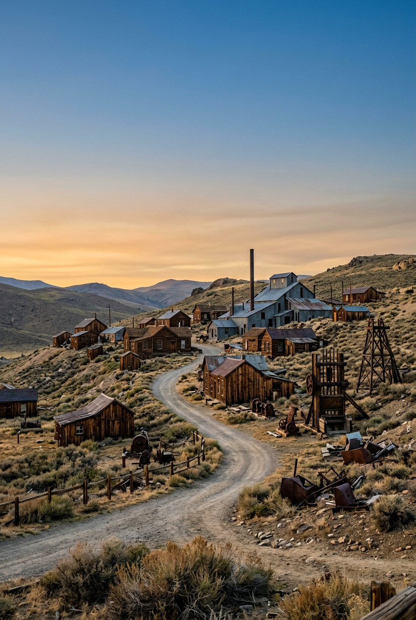
Cobalt, Ontario (silver rush town)
- Historical snapshot: Cobalt exploded in the early 1900s during a silver rush, transforming a northern Ontario landscape into a global mining hub. The mines shaped early Canadian capital flows and immigrant settlement patterns.
- Why go: Turn-of-the-century mine shafts, historic buildings, and a very local museum that preserves miners’ stories and artifacts.
- Practicalities: Location — 47.3891° N, 79.6836° W. Driveable from North Bay (about 1 hour). A walking tour map from the museum highlights heritage buildings and mining relics.
- Tips: Don’t enter old mine openings. Wear insect repellent in summer and check museum hours which are seasonal.
Fort St. James, British Columbia (fur trade outpost but listed here for central placement)
- Historical snapshot: Established in 1806 by the North West Company, Fort St. James is a well-preserved fur trade post with log structures and living history demonstrations.
- Why go: The site shows colonial fur trade economics, Indigenous partnerships and conflict, and offers an unusually intact set of 19th-century structures.
- Practicalities: Location — 54.4225° N, 124.1653° W. Drive or fly to nearby regional centers; site is run by Parks Canada and often hosts reenactments.
- Tips: Respect living history volunteers, and combine the stop with nearby natural exploration of Lake St. James.
Western Canada & North: remote, Indigenous and dramatic
Barkerville, British Columbia (Cariboo Gold Rush)
- Historical snapshot: Barkerville grew fast after the 1860s gold rush and preserved a full town layout with general stores, theatres and miner’s cabins. It’s a living town museum, but outside peak season the place has a quiet, almost ghostly feel.
- Why go: Experience a working heritage town that still interprets miners’ daily lives, Chinese immigrant stories and the supply chains behind the rush.
- Practicalities: Location — 53.0595° N, 122.0119° W. Accessible by paved road from Quesnel. High season has living historians; off-season some buildings close.
- Tips: Book evening talks if available; explore the adjacent trails to see miners’ sluice works and artefact scatters.
SGang Gwaay (Ninstints), Haida Gwaii, British Columbia
- Historical snapshot: SGang Gwaay is an ancient Haida village with monumental totem poles and longhouse remains. A UNESCO site, it was abandoned in the 19th century, and the standing poles are among the finest examples of northwest coast carving.
- Why go: One of Canada’s most important Indigenous archaeological sites. The combination of rainforest, sea cliffs and totems creates a unique aesthetic and cultural significance.
- Practicalities: Location — southern Moresby Island, Haida Gwaii (exact coords 53.1310° N, 132.0262° W). Access by boat from Sandspit or Skidegate; tours operate seasonally. Permission and respectful behaviour are required; local Haida guides often provide the best context.
- Tips: Hire a Haida guide when possible, observe cultural protocols, and never climb on or touch totems. Photography rules may apply.
Beechey Island, Nunavut (Arctic Franklin expedition graves)
- Historical snapshot: Beechey Island is where members of Sir John Franklin’s 1845 polar expedition were buried — some of the earliest archaeological sites associated with attempts to chart the Northwest Passage. The island holds graves, artefacts and a compact but powerful chapter of Arctic exploration.
- Why go: It’s deeply historical and quietly haunting — a chance to see polar monuments and reflect on exploration’s human cost.
- Practicalities: Location — 76.2833° N, 82.9000° W. Extremely remote: small-ship cruises in the high Arctic and specialized expeditions include Beechey Island. Travel is seasonal (short Arctic summer) and expensive; permits and careful logistical planning are required.
- Tips: Travel with a reputable operator experienced in polar ethics and archaeology. Do not disturb grave sites. Read expedition histories beforehand to contextualize what you’ll see.
Keno City, Yukon (silver mining)
- Historical snapshot: Keno City was at the heart of Yukon silver mining. Its tiny population and standing wooden buildings recall a more frenetic mining era; nearby relics and old equipment litter the hillsides.
- Why go: Keno City is a living half-town with deep mining history and well-preserved period architecture, strikingly perched in subalpine terrain.
- Practicalities: Location — 63.5711° N, 135.8239° W. Access by road (some gravel) from Mayo; be prepared for limited services and seasonal access. The local community runs small museums and offers tours.
- Tips: Fuel up in advance, carry extra supplies, and check weather and road conditions before driving gravel connectors.
Practical travel and safety tips for hidden historic sites
Before you go
- Research local stewardship: Many historic sites are cared for by small heritage societies or Indigenous governments — check their websites for visitor rules and hours.
- Permit and access checks: For remote sites (Beechey Island, Haida Gwaii, Sable Island), you’ll need tour operators or park permits; never attempt unsanctioned landings.
- Maps and navigation: Download offline maps (Gaia GPS, Avenza, or Google offline tiles). Many of these places have limited or no cell coverage.
- Respect private property and cultural restrictions: If a site is on private land or has restricted areas, obey gates and signage.
On site
- Do not remove artefacts: Taking nails, bricks or objects damages archaeological contexts — and it’s often illegal.
- Stay on designated trails: Foot traffic can ruin fragile building foundations and archaeological deposits.
- Photo etiquette: For Indigenous sites like SGang Gwaay or Red Bay, check photography rules. Ask permission before photographing people.
- Safety in ruins: Old structures can collapse. Observe from a safe distance; don’t enter unstable buildings.
Seasonal considerations
- Summer is primary for remote sites due to access and weather, but shoulder seasons sometimes offer quieter visits. Winter travel into remote northern sites is specialized and should be done with guides.
- Mosquitoes in boreal and northern summer: pack repellent and head nets.
Responsible travel and working with Indigenous communities
- Learn before you arrive: Read local Indigenous histories and site-specific interpretation to understand context.
- Hire Indigenous guides: Many sites (SGang Gwaay, Red Bay) offer Indigenous-led tours that provide depth and ensure benefits flow to local communities.
- Leave no trace and support local stewards: Donations, museum purchases, and tour bookings help preserve fragile sites.
Mapping and logistics checklist
- Offline map apps downloaded and waypoints saved for each site.
- Fuel and spare tires for gravel/remote roads.
- Contact numbers for local heritage societies, Parks Canada, or Indigenous offices.
- First aid kit, insect repellent, and appropriate footwear.
- Cash for small museums and local crafts — many remote gift shops do not take cards.
Sample 7–10 day itinerary ideas
If you have one week and want a historic loop (example: Atlantic focus)
Day 1–2: St. John’s, Newfoundland — visit small museums and ferry to Bell Island for mine history. Day 3–4: Tilt Cove and nearby coastal ruins on the Avalon Peninsula. Day 5–6: Fly or drive to Labrador to reach Red Bay (seasonal) — combine with local cultural programming. Day 7: Return and debrief in St. John’s with museum time.
If you’re western-bound (BC cluster)
Day 1: Fly to Vancouver, ferry to Haida Gwaii. Day 2–3: SGang Gwaay guided tour and Haida cultural experiences. Day 4–5: Back to mainland, drive to Quesnel and Barkerville open-air museum. Day 6: Combine Barkerville with local trails and history talks.
Research and reading list (start here)
- “The Basque Whaling Industry and Red Bay” — Parks Canada materials and UNESCO documents.
- Local museum websites (Cobalt Mining Museum, Bell Island Heritage Society).
- Haida Nation publications and resources for respectful visitation.
- Archives of regional newspapers (for mining rush coverage and personal accounts).
Why these hidden places matter
Hidden historic sites are rarely just old walls. They are nodes where economy, empire, environment and everyday life collided. They reveal migration patterns, colonial violence, technical ingenuity, and local responses to boom-and-bust cycles. Visiting them can shift your understanding of Canada from a postcard to a layered human landscape.
Final planning tips
- Time of day: Early morning light is best for photos and quiet reflection; late afternoon can bring dramatic shadows on ruins.
- Weather: Coastal sites often have fast-changing weather. Pack a lightweight waterproof layer and a warm midlayer even in summer.
- Health: Remote sites may require hiking or rugged walks; check fitness levels and bring poles if needed.
Conclusion
These hidden places to visit in Canada give you old maps, new questions and a sharper sense of how people carved livelihoods from forest, sea and ore. They take a little more planning than national parks, but the payoff — preserved stories, rare landscapes and quieter moments of history — is worth it. Start with one site near you, read the local accounts first, and go prepared.
Call to action
Which historic hidden spot intrigues you most? Pick one, check the local heritage society site for visitor information, and plan a respectful trip. If you enjoyed this list, subscribe to Chieftourist for more offbeat Canadian travel writing and detailed itineraries.